This page contains automatically translated content.
University of Kassel drafts hazard map for heavy rainfall
Dr.-Ing. René Burghardt, a member of staff in the Department of Landscape Planning and Communication at the University of Kassel, developed this interactive map in cooperation with the engineering firm Burghardt und Partner: "We use it to record natural or artificial hollows and depressions that absorb and/or transfer water masses during heavy rainfall. This enables us to identify areas in the city of Kassel that could be affected by high water and flooding and subsequently initiate preventative measures in urban and landscape planning," he explains.
The heavy rain hazard map is initially based on a computer-aided calculation, known as BlueSpot Mapping. By collecting a wide range of data for the city of Kassel, Burghardt wants to compare the computer model with reality and improve it.
Burghardt is asking citizens to help with the data collection: "We would be delighted if you could mark locations on the map where flooding has occurred. You can mark these with your subjective assessment of the intensity of the flooding. You also have the option of uploading a photo." No user-related data is stored, the report is anonymous.
Burghardt's team can use the data to prioritize areas that are particularly relevant for planning in the context of heavy rainfall, for example. "On the one hand, we want to use the model to identify risk areas so that we can introduce protection and adaptation measures," explains landscape planner and urban climatologist Burghardt. "On the other hand, we want to identify potential areas that are suitable for preventative measures, such as (natural) rainwater retention areas. As a result, we want to develop tips for urban and landscape planning as a contribution to climate adaptation." The model is currently designed for the city and region of Kassel, but is to be implemented for the entire region of North Hesse in the long term.
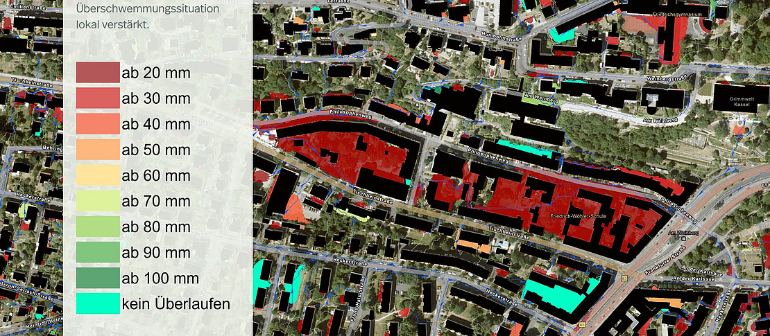
Burghardt's model is based on the so-called BlueSpot Mapping, which was developed by the University of Copenhagen and the city after the massive floods in Copenhagen (Denmark) in 2011. A "BlueSpot" is a natural or artificial depression or hollow that is defined by the surface (topography), but also by buildings. The BlueSpot has a certain capacity. The model calculates the amount of incoming water at which a BlueSpot overflows and drains the excess water into a lower-lying BlueSpot. In the further calculation steps, the model takes into account, among other things, the proportion of vegetation and degree of sealing for each surface catchment area and each BlueSpot. From this, planning statements can ultimately be derived for the protection and prevention of areas and spaces.
Heavy rainfall in the Kassel region (2023) (arcgis.com):
https://storymaps.arcgis.com/stories/c471730126b8485c9ab8eb816152e1ad
Contact:
Dr.-Ing. René Burghardt
University of Kassel, Faculty of Architecture, Urban Planning and Landscape Planning
Department of Landscape Planning and Communication
Mail: r.burghardt[at]uni-kassel[dot]de